Last week we talked a little bit about the Plank Road, but I should have really started with earlier roads and ways of traveling in the late 18th and early 19th centuries when white settlers were first making their way to the area which encompasses Cortland County today. The Tioughnioga River was one of the primary methods of transportation for the Indigenous peoples of this area along with well-traveled land trails. These methods of travel were perfect for people without horses and wagons, but not conducive to ox carts laden with people and household goods traveling from New England and other places.
One of the primary trails that was utilized by Indigenous peoples (including the Mohawk and the Haudenosaunee) was a trail that followed the Tioughnioga River from the south. Not only did people travel by land on foot, but they also used boats or canoes to traverse the waterways. From the Manlius and Cazenovia areas in the north then through the Cuyler and Truxton valleys and on into Cortland was another often-utilized trail. [Side note: I once got lost somewhere over in that area (probably a Boy Scout-related venture or a homeschool adventure gone awry) and I can see how there was a need for better transportation, even now!] There was another trail from Cayuga Lake which passed through McLean, Cortland, Homer, and Preble.
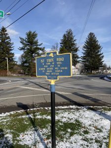
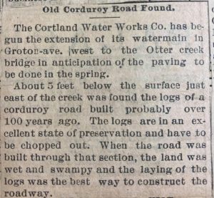
Joseph Chaplin came to the area in 1792 and was the first white settler in Virgil. He was contracted by the state of New York to make the first road in the area. It was completed in 1793-94. It connected Oxford, Chenango County to Ludlowville, Cayuga County and was approximately 60 miles long. It entered Cortland County in Willet and passed through Marathon to Virgil. If you have ever traveled up over the hill from Messengerville to Virgil, you have been on the “Old State Road.” When we think of roads, we picture paved roads. Though we still have plenty of dirt roads, this road was the poor cousin of our worst dirt road today. It was narrow, barely a path cut through the thick forest, and it had many “corduroy” stretches which got a traveler past low, swampy areas. Last week, one of the comments on the Plank Road feature pertained to corduroy roads, another term I was unfamiliar with until recently when I discovered the small newspaper clipping included in the photos. A corduroy road was discovered over in the Otter Creek area in this undated clipping. This area was not good land for farming due to a large number of marshy areas. Swamps were drained and the landscape altered in order to build homes, barns, and businesses as well as to establish cropland. It was better suited to grazing animals than to growing crops in many areas. [Side note: The historical societies in Marathon and Virgil organized a couple of trips that followed the Chaplin Road. I was unable to go on either of the excursions, but I heard they were great fun.]
A second “major” road was opened shortly after the Old State Road, and it was called the Old Salt Road. This road ran from Binghamton to the Salina Salt Works. It ran through Marathon and Freetown where it was “cut” by the Old State Road. In Bertha Blodgett’s “Stories of Cortland County,” she states that parts of the road were still to be seen in Marathon, Solon, and Truxton. “Stories” was first published in 1932, though it began as a series of newspaper articles written specifically for children in 1930. “Cortland County Chronicles, Volume 2,” published in 1958, also mentioned areas still in use. Other roads built after the Old State Road and the Old Salt Road were those which ran from the Old State Road to Homer and on towards Syracuse (part of the Albany Turnpike) and one from Port Watson to Solon. In 1806, a road was built from Cortland to Virgil.
Over the next couple of weeks, we will look at turnpikes, bridges, and railroads. We might also detour into water travel with the arks at Port Watson and the changes wrought by the Erie Canal. Transportation is truly a fascinating topic, and this little detour in our “Streets of Cortland” series is the smallest sliver of an introduction into the world of getting from Point A to Point B from the 1790s to the end of the 1800s. It helps to understand history when you look at the big picture topics like transportation. ~Tabitha


